New intra-day satellite imagery of the Korla East Test Site in Xinjiang, China, shows the operation of laser anti-satellite weapons (ASAT) to engage with Western satellites.
The satellite imagery from geospatial intelligence company BlackSky has uncovered a pattern of behaviour at the Korla East Test Site that is consistent with China’s development of technology to disrupt, destroy or hijack foreign satellites, as mentioned in the recent US intelligence breach.
Go deeper with GlobalData

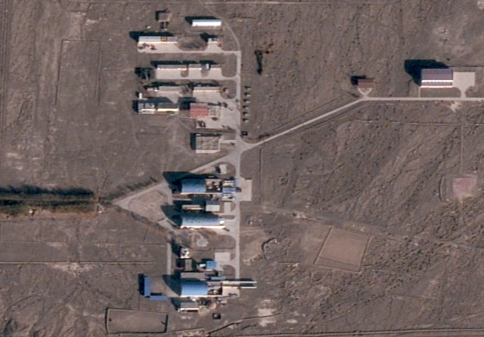
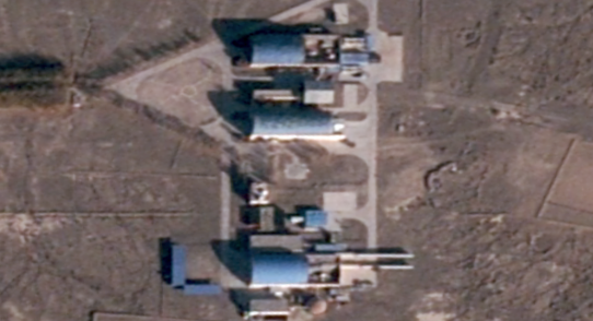
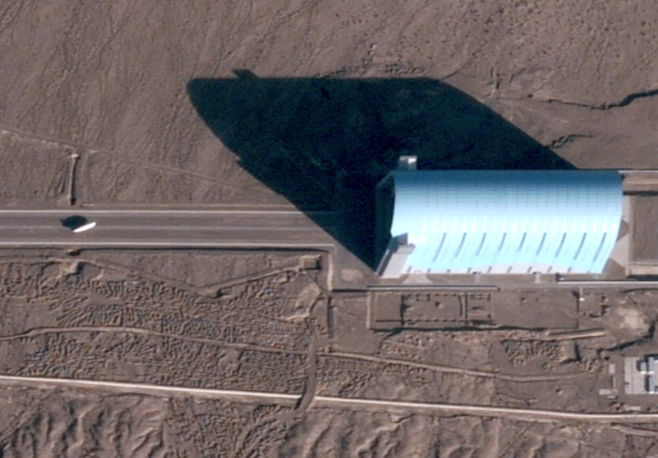
Army Technology has reviewed satellites images of Korla East Test Site featuring two laser gimbals with supporting infrastructure, housed within separate hangars with retractable roofs, to the north and south of the compound, confirming the view that this site holds ASAT weapons. The evidence suggests a pattern of opening the hangars to operate the ASAT lasers around solar noon, the time when foreign imaging satellites are most active.
According to satellite tracking data for a sample of days within the observation period, a large number of satellite companies orbited within line of sight of the facility during active ASAT periods, including SpaceX’s Starlink communications satellites, and constellations of commercial geo-imaging satellites that include the companies Spire and Planet labs. National military satellites may also have been active in the region during this time, but their orbits are not public knowledge.
The use of ASAT systems at the Korla East Test Site is in line with details that emerged from the leak of classified CIA documents in April 2023. The Financial Times reported the documents included concerns that China is developing technology “to seize control of a satellite, rendering it ineffective to support communications, weapons, or intelligence, surveillance, and reconnaissance systems”.
See Also:
The ASAT located at Korla East Test Site are laser directed-energy weapons that have uses that may vary from dazzling and disrupting a satellite’s communications and optical sensors, to heating a target for a separate engagement with heat-seeking missiles, or even directly destroying satellite components.
How well do you really know your competitors?
Access the most comprehensive Company Profiles on the market, powered by GlobalData. Save hours of research. Gain competitive edge.

Thank you!
Your download email will arrive shortly
Not ready to buy yet? Download a free sample
We are confident about the unique quality of our Company Profiles. However, we want you to make the most beneficial decision for your business, so we offer a free sample that you can download by submitting the below form
By GlobalDataLaser ASAT could also be used to harvest data from a satellite by spoofing an encrypted point-to-point laser information transfer, as described by Neil Sherwin-Peddie, head of space security BAE Systems Digital Intelligence, after the company forecasted the first major hack of a satellite in 2023. “The adversary can use satellite blinding as these satellites pass to capture critical imagery or radio frequency data.”
EMP generator and aerostat blimp also at site
Other features in the imagery from the desert-based Korla East Test Site are also raising questions.
Co-located with ASATs at the facility are an electromagnetic pulse (EMP) generator used in research to protect and harden technology against nuclear EMP incidents; and a newly discovered aerostat military blimp, captured for the first time at Korla East by BlackSky. Given the size of the aircraft, roughly 31m in length, the aerostat is thought to be either a CA-30R or CA-32R.
An intelligence analyst familiar with the location and imagery said this was of interest because a military organisation would not normally house these unusual and unrelated technologies in the same remote location without a shared purpose or interconnection between them.
The electromagnetic pulse research site at Korla East Test Site is located 3km south of the main facility, and its distinctive appearance is similar to the Nuclear Electromagnetic Pulse test system in Switzerland build by Montena Technology. These systems use horizontally polarised dipoles to simulate an EMP attack and can be used to test equipment for its resistance against such electronic warfare.

An aerostat is a platform that naturally lends itself to EMP protection, according to a 1997 Whitehall Paper journal article on the subject, with blimps’ capacity to remain airborne not vulnerable to this form of electronic warfare in the same manner that other aircraft would be susceptible, although many electronic subsystems would still need ruggedisation. The CA-30R and CA-32R are remotely controlled blimps capable of being adapter for aerial survey, photography, and surveillance missions. They have small gondolas that are not equipped with controls for an onboard pilot.
Geospatial intelligence analysis of the Korla East Test Site
BlackSky operates a constellation of 16 satellites that orbit along the Earth’s equator, in contrast to conventional geospatial intelligence companies that operate satellite constellations with polar orbits. Although the area covered by BlackSky’s unusual pattern of orbits is smaller, it still captures 95% of the human activity related to gross domestic production worldwide.
This pattern of orbit also means that the BlackSky constellation can return to a site with a much higher frequency. Most people on earth will be under a BlackSky satellite every hour, and BlackSky can return satellite imagery within 90 minutes of any request. The industry standard elsewhere is to handle requests within a few days or a week.
Up until this point analysis of the activity pattern on the site had been hampered by latency and infrequent observation, but BlackSky’s low-latency satellite constellation allowed for intra-day collections, capturing 200 images at Korla East Test Site, with observations made in a sample of all daylight hours across the period of 24 April to 9 June 2022.
An intelligence analyst familiar with the location and imagery found increased laser ASAT activity around solar noon – the time-of-day conventional satellites collect images for intelligence operations.
| Local time of image collection | Hangar roof retraction rates | |||
| Start | Stop | Number of image collections | Northern Hangar | Southern Hangar |
| 4:00 | 5:00 | 1 | 0% | 0% |
| 5:00 | 6:00 | 10 | 0% | 0% |
| 6:00 | 7:00 | 14 | 7% | 7% |
| 7:00 | 8:00 | 17 | 6% | 6% |
| 8:00 | 9:00 | 18 | 17% | 11% |
| 9:00 | 10:00 | 18 | 39% | 50% |
| 10:00 | 11:00 | 19 | 100% | 89% |
| 11:00 | 12:00 | 15 | 67% | 73% |
| 12:00 | 13:00 | 12 | 50% | 17% |
| 13:00 | 14:00 | 10 | 10% | 10% |
| 14:00 | 15:00 | 13 | 46% | 15% |
| 15:00 | 16:00 | 17 | 65% | 6% |
| 16:00 | 17:00 | 9 | 44% | 11% |
| 17:00 | 18:00 | 10 | 90% | 0% |
| 18:00 | 19:00 | 11 | 45% | 9% |
| 19:00 | 20:00 | 6 | 17% | 33% |
| Total for all hours | 200 | 42% | 26% |
The most intense periods of activity were between 10am and 1pm, when a total of 46 images were collected. For example, in the 19 images collected just between 10am and 11am, the northern hangar was open to allow the laser ASAT to engage with satellites in every instance, and the southern hanger was open 89% of the time.
For other companies in the commercial geospatial intelligence industry, the period around solar noon is the optimal time for capturing and collecting images of the ground to avoid the blocking effects of shadows. Most image collection in the commercial industry occurs in this time, and the uptick in activity at the Korla East Testing Site at this point suggests the use of the ASAT to engage with this class of satellite.
This trend is underscored by the observations BlackSky made between 5am and 6am, when long shadows make commercial observation operations unlikely. Of the 10 observations made in this interval neither hangar containing an ASAT was open at any point. The data also showed a rise in the percentage of hangar openings for the northern ASAT weapon later in the day. It is possible that this corresponds to a rise in activity for satellites without publicly logged orbits, such as military and national government satellites.
In images viewed by Army Technology, the ASAT lasers are visible within the hangar when the roof is retracted. The laser has two large shoulders and a protruding lens, similar in outline to the China-made Silent Hunter low altitude laser air defence system, demonstrated at the 2017 International Defence Exhibition & Conference. The major difference is the size of the systems. The Silent Hunter is a car mounted tactical system, while the of the ASAT system visible at Korla East Testing Site is much larger, closer in size to a system that would be mounted on a naval vessel. The southern hangar containing a laser also featured a forward door, suggesting the laser was also tested to engage targets at ground level.
The building layout at Korla East Testing is consistent with other locations in China that have advanced laser capabilities. Both hangers are connected by pipelines to large hemispherical buildings that resemble constructions at the Chinese Academy of Engineering Physics and the Anhui Institute of Optical and Fine Mechanics. These domed structures are known to house gas required during the operation of lasers.

An intelligence analyst familiar with the location and imagery said that within and around the hangars it was possible to identify transportable modules resembling an EMP protected system that is often found in forward operating locations for mission critical functions such as command, control, and communications.
Korla East Test Site Designation
The Korla East Test Site was first built in 2003 and has seen a great deal of expansion since then, but much of the construction history prior to 2005 remains undocumented.
Research conducted by Jeffrey Lewis, a member of the State Department International Security Advisory Board, and Eli Hayes, published on Arms Control Wonk, suggested that the Korla East Test Site is managed by a previously unidentified unit, known as Unit 63655 of the Strategic Support Force (SSF). This assessment is based on an analysis of research published by the unit and geographical evidence supporting it being located at this point.
Upon examination, Lewis and Hayes found that the patents assigned to Unit 63655 can be classified into three primary categories: studies delving into lasers and optics; studies into stratospheric airships of considerable size; and studies of high-powered microwaves. In their account, Hayes and Lewis said that Korla East Test Site is the only site that has the capacity to host infrastructure for these three categories of research. Furthermore, the unit has released meteorological analyses with a primary emphasis on the regions surrounding the Bosten Lake vicinity, located immediately to the north of the Korla East Test Site.
They went on to say that the evidence suggests Unit 63655 serves as the administrative headquarters for the Korla East Test Site, with the proviso that while no single piece of evidence is conclusive, the collective information points towards this conclusion.