
We’d be lost without GPS. It’s hard to imagine a world without our satellite-based location finder, but it only reached full operational capability (FOC) in 1995; for perspective, The X-Files was first broadcast two years before that.
Owned by the US Government and operated today by the US Space Force, GPS is freely accessible by anyone with a GPS receiver and has irreversibly changed the face of military operations and civilian navigation. Its first use in military operations was during the Persian Gulf War in 1991 before it was even fully developed, and it has remained an essential resource ever since.
Go deeper with GlobalData

Discover B2B Marketing That Performs
Combine business intelligence and editorial excellence to reach engaged professionals across 36 leading media platforms.
To celebrate the 25h anniversary of the technology, the US Space Force launched a campaign to help educate the public on this critical, and often overlooked, mission, highlighting the huge impact GPS has had on our everyday lives, and sharing how GPS works and its history.
The past, present and future of GPS
The origins of GPS can be traced back to an effort by the US Navy in the 1950s to develop systems that could track latitude and longitude, principally the Transit navigation system to provide location information for its Polaris ballistic missile submarines.
“That system, however, did not use three dimensions like GPS today,” says a US Space Force spokesperson. “Likewise, navy scientist Roger Easton led the development of a system known as Timation, short for timed navigation, that used atomic clocks. At the same time, the US Air Force (USAF) was working on what was known as 621B, while the US Army also had a satellite navigation project.
“Eventually, the Department of Defense (DoD) decided to bring these three programmes together and did so in 1973 by assigning the air force as the executive agent. USAF Colonel Bradford Parkinson was placed in command of the Joint Program Office to run the combined Navstar GPS programme, which basically combined the best of the army, navy and air force’s efforts into a single programme and that could track location in three dimensions; latitude, longitude, and altitude.”
The first conflicts where GPS offered a strategic advantage were the Gulf War Operations Desert Shield and Desert Storm from 1990 to 1991, and it quickly became integral to all military operations.
“Today, there isn’t a joint operation that doesn’t integrate space capabilities – the pervasiveness of these capabilities and the information they provide is a key ingredient to how American forces operate with unmatched speed, precision, and lethality,” says the Space Force spokesperson.
“Our GPS capabilities help ensure our military leaders can see the battlespace with clarity using Blue Force Tracking, strike with precision, navigate with accuracy, communicate with certainty, understand weather impacts, and operate anywhere in the globe.”

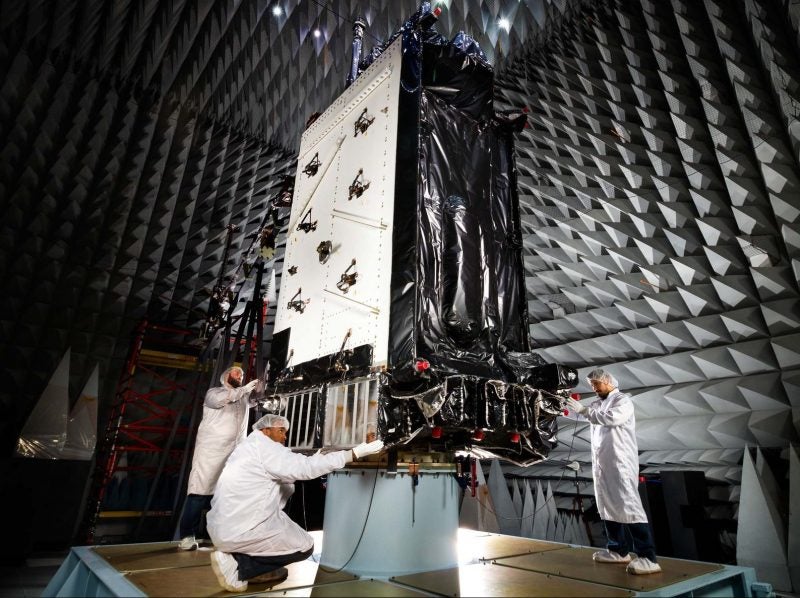
The GPS III SV03, here shown during integration, was launched on 30 June. Image: Lockheed Martin
Technology will not wait – neither will we
Since then, GPS-enabled military capabilities have transformed the battlefield, including the recent development of GPS-guided ‘smart pallets’ that enable aircrews to conduct precise resupply missions, and the next generation of GPS means more breakthroughs are on the way.
The first two next-generation GPS III satellites, or space vehicles (SVs) as they are called, GPS III SV01 and GPS III SV02, launched on 23 December 2018 and 22 August 2019 and were declared operational in the constellation on 13 January and 1 April 2020, respectively. GPS III SV03 was launched in June 2020 and, once it gains operational acceptance, will further improve the GPS constellation.
“These improvements will increase the fidelity of the GPS signal, improve resistance to GPS jamming and cyberattacks, boost military signal strength, and add civil signals,” says the Space Force spokesperson. “For the other domains, our space systems enable a more lethal, resilient, and agile joint force to deter and defeat aggression by strategic competitors.“Once fully operational, GPS-III satellites will bring new capabilities to users, including three times greater accuracy and up to eight times the anti-jamming capabilities. Technology will not wait – neither will we.“The US prefers that space remain free of conflict, but recognises that space has become a warfighting domain, and we must be prepared to operate in that environment, just as we do in other domains. We will modernise systems and equipment at the speed of relevance.”
Responsibility for delivering GPS III satellites into orbit lies with US Space Force’s Space and Missile Systems Centre (SMC), which operates out of Los Angeles Air Force Base. SMC’s GPS III programme office delivers advanced GPS satellites which provide a Military Code (M-Code) signal with greater security, higher power and improved availability and accuracy. GPS III SV01, SV02 and SV03 add three more M-code-capable satellites to the 19 M-Code satellites already in orbit today from the GPS IIR-M and GPS IIF programmes.
For civilian users, the GPS III programme provides navigation and timing to a broad spectrum of civil users. It also transmits a brand new fourth civil signal, which is compatible with the European Galileo satellite navigation system signal and those signals planned for broadcast on Japan’s Quasi-Zenith Satellite System, a system designed to augment GPS services.
Each GPS III space vehicle (SV) undergoes a rigorous battery of tests throughout production which culminate after a successful launch.
“As the SVs are constructed, a series of manufacturer component integration and assembly tests check each major sub-system after installation,” the SMC says. “Then the SV completes both an acoustic chamber test to simulate its jarring ride to space and a thermal vacuum test to validate performance in a space-like environment. Next, the SVs are subjected to mechanical and electrical tests prior to launch to confirm proper operation of all the spacecraft systems.
“Finally, after launch, the SV completes a series of on-orbit checkout tests to verify the health of the entire SV while on-orbit before declaring the vehicle is operational for global use.”
After a delay due to the coronavirus pandemic, the GPS III SV03 launched from Cape Canaveral Air Force Station, Florida on 30 June, aboard a SpaceX Falcon 9 rocket, which will attempt a post-launch first stage booster recovery.
“GPS III SV03 will be the first National Security Space Launch Mission in which a first stage booster recovery will be attempted,” the SMV told us ahead of the launch. “This also marks the first time that a GPS spacecraft will ascend to its operational position within the constellation from a lower orbital altitude upon release from an upper stage. That in itself makes for an historic launch attempt.”
GPS III SV03 will be monitored until the end of July, ensuring its reliability after it is set to ‘healthy’ within the constellation. GPS III SV04 is set to launch in autumn 2020 aboard a SpaceX Falcon 9 Rocket, GPS III SV05 was declared available for launch in May 2020, and SVs 06 through 08 are currently undergoing vehicle level testing.

GPS III SV02 loading for shipment to Cape Canaveral. Image: Lockheed Martin
Lockheed Martin’s work on GPS
Lockheed Martin is the prime contractor responsible for the procurement and assembly of GPS III space vehicles and subcomponents and SMC’s GPS III programme office works side by side with the company through a shared relationship.
Lockheed has more than 30 years of experience with GPS. It was awarded the first contract to build 20 GPS IIR satellites in 1989 and began launching them in 1997. In 2000, the Air Force awarded Lockheed Martin a contract to modernise the final eight GPS IIR satellites under contract, which became the GPS IIR-M satellites.
“Today, Lockheed Martin GPS satellites make up about 60% of the current 31 satellite operational constellation,” Lockheed Martin Space acting vice president for navigation systems Tonya Ladwig says. “This includes ten GPS IIR, seven GPS IIR-M and two – soon to be three – new GPS III satellites.
“The GPS IIR and IIR-M satellites have performed remarkably on orbit, with many of them continuing to deliver on their positioning, navigation and timing mission long past their original planned 7.5-year design life. That said, they were designed with the most advanced technology available and for the capability needs of the decades they were launched in. But technology changes fast.”
As part of the USAF’s overall plan to modernise GPS, including the satellite constellation, the ground control system and military user equipment, in 2008 Lockheed Martin was awarded a contract to design the GPS III satellite.
“GPS III is being designed and built at Lockheed Martin’s GPS III processing facility near Denver, Colorado,” says Ladwig. “It is a special manufacturing facility that was designed in a virtual reality environment to layout a very commercial-like production line that allows for smooth and efficient satellite assembly and testing through a series of work cells.”
Of course GPS, like most space systems, isn’t run by satellites alone; the USAF’s ground control system that controls the satellites is called the Operational Control Segment (OCS).
“We’ve been working closely with the USAF and the Space Force to maintain and continuously upgrade the OCS, updating its software and hardware, and hardening its cybersecurity to ensure the USAF can perform its mission,” says Ladwig.

GPS III SV01 encapsulated in its launch fairings for launch. Image: Lockheed Martin
Ongoing and future GPS upgrades
Ladwig says the pace of technology has accelerated further in recent years, adding: “We believe continued investment in GPS – adding new technology and updated capabilities to the GPS constellation – is critical to maintaining the system as the ‘gold standard’ for positioning, navigation and timing around the world.”
This includes the GPS III Follow On (GPS IIIF) programme, which the USAF awarded to Lockheed Martin in September 2018, after a full and open competition.
“The initial contract of $1.4bn includes the production of GPS IIIF space vehicles 11 and 12, as well as non-recurring engineering, a new GPS IIIF non-flight satellite testbed, new GPS IIIF flight simulators, eventual space vehicle storage, launch support and on-orbit support,” says Ladwig.
“This is the initial order following the air force’s 14 September 2018 announcement it had selected Lockheed Martin to build up to 22 GPS IIIF satellites, with an estimated contract value of $7.2bn. We are currently finishing up our design review for the GPS IIIF programme and are ready to start on hardware development.”
GPS IIIF builds off GPS III’s innovative modular design, which allows the addition of new technology when it becomes available. New capabilities will include a regional military protection capability, which will increase anti-jam support in theatre to ensure US and allied forces cannot be denied access to GPS in hostile environments, a fully digital navigation payload and a laser retro-reflector array, which allows the positioning of on-orbit satellites to be refined with ground-based, laser precision.
Additionally, the US Government will provide each GPS IIIF with a new search and rescue payload that will make it easier for first responders to detect and respond to emergency signals.
Ladwig explains that when planning future GPS solutions Lockheed Martin looks at its customer’s positioning navigation and timing mission holistically and as a full mission partner, with GPS satellites as the backbone for this mission, but other systems augmenting the system.
An example is the Next-Generation Satellite Based Augmentation System which Lockheed Martin has developed and tested in Australia. It uses signals from both GPS and Galileo constellations and dual frequencies to achieve greater global navigation satellite system integrity and accuracy.
“Another example is Dark Ice, a new magnetometer technology Lockheed Martin is developing that uses magnetic sensing as an alternative means of determining your location without the use of satellite signals,” Ladwig says. “As far as GPS satellite technology goes, it will continue to grow in sophistication, using more augmented reality and digital technologies in production, and providing advanced new capabilities, like on-orbit re-programmability in the constellation in the future.”
Beyond the US DoD’s major partners, the success of GPS owes much to a number of specialist manufacturers. One of these, optronics specialist Excelitas, manufactures the rubidium atomic frequency standard (RAFS) space-qualified atomic clocks that are essential to GPS providing highly-accurate timing and frequency signals.
“Excelitas’ high-reliability RAFS technology was developed specifically for mission-critical space applications,” says Excelitas Technologies technical director of RAFS systems John Vaccaro. “We have built over 140 atomic standards with world-class stability and low drift combined with the small size, low weight, and power advantages. The Excelitas RAFS is recognised as an enabling technology for GPS.”
Partnerships between allied powers are also vital to the success of GPS.
“Today’s partnerships are vital in the contested space environment,” the Space Force spokesperson concludes. “Partnerships such as those we have with the UK strengthen our advantage and complicate potential adversary decision-making. We have worked hard to build strong allied and commercial space partnerships.
“Globally, more than 3.6 billion global navigation satellite system devices rely on the US Space Force-provided GPS signals. Not only is GPS critical to joint warfighters, it is critical to our way of life.”
