The aerospace and defense industry continues to be a hotbed of patent innovation. Activity is driven by the pressing need for modernization, and the growing importance of technologies such as artificial intelligence (AI), Internet of Things (IoT), and unmanned systems. In the last three years alone, there have been over 237,000 patents filed and granted in the aerospace and defense industry, according to GlobalData’s report on Internet of Things in defense: LiDAR weather forecasting. Buy the report here.
Smarter leaders trust GlobalData

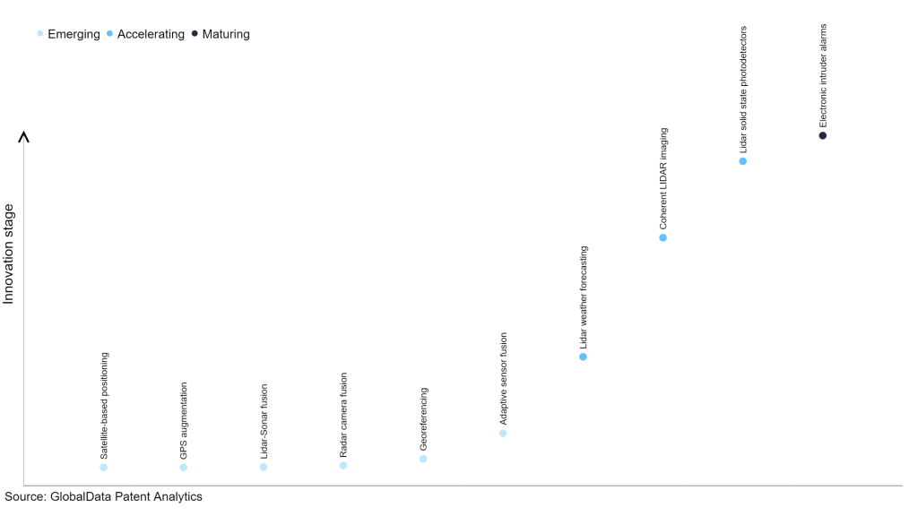
However, not all innovations are equal and nor do they follow a constant upward trend. Instead, their evolution takes the form of an S-shaped curve that reflects their typical lifecycle from early emergence to accelerating adoption, before finally stabilizing and reaching maturity.
Identifying where a particular innovation is on this journey, especially those that are in the emerging and accelerating stages, is essential for understanding their current level of adoption and the likely future trajectory and impact they will have.
110 innovations will shape the aerospace and defense industry
According to GlobalData’s Technology Foresights, which plots the S-curve for the aerospace and defense industry using innovation intensity models built on over 206,000 patents, there are 110 innovation areas that will shape the future of the industry.
Within the emerging innovation stage, satellite-based positioning, GPS augmentation, and LiDAR-sonar fusion are disruptive technologies that are in the early stages of application and should be tracked closely. LiDAR weather forecasting, coherent LiDAR imaging, and LiDAR solid state photodetectors are some of the accelerating innovation areas, where adoption has been steadily increasing.
Innovation S-curve for Internet of Things in the aerospace and defense industry
LiDAR weather forecasting is a key innovation area in Internet of Things
Light detection and ranging (LiDAR) weather forecasting refers to the use of LiDAR systems to detect weather conditions and forecast meteorological phenomena. LiDAR is a remote sensing technology that uses laser beams to measure distances and gather data about objects and the surrounding environment. In the context of weather forecasting, LiDAR systems can be used to measure air characteristics, detect objects in the environment, and provide real-time data for accurate weather predictions.
GlobalData’s analysis also uncovers the companies at the forefront of each innovation area and assesses the potential reach and impact of their patenting activity across different applications and geographies. According to GlobalData, there are 40+ companies, spanning technology vendors, established aerospace and defense companies, and up-and-coming start-ups engaged in the development and application of LiDAR weather forecasting.
Key players in LiDAR weather forecasting – a disruptive innovation in the aerospace and defense industry
‘Application diversity’ measures the number of applications identified for each patent. It broadly splits companies into either ‘niche’ or ‘diversified’ innovators.
‘Geographic reach’ refers to the number of countries each patent is registered in. It reflects the breadth of geographic application intended, ranging from ‘global’ to ‘local’.
Patent volumes related to LiDAR weather forecasting
| Company | Total patents (2021 - 2023) | Premium intelligence on the world's largest companies |
| Huawei Investment & Holding | 2 | Unlock Company Profile |
| Lyft | 2 | Unlock Company Profile |
| COSCO Shipping | 2 | Unlock Company Profile |
| Mercury Systems | 1 | Unlock Company Profile |
| Ball | 6 | Unlock Company Profile |
| MBDA | 4 | Unlock Company Profile |
| Michigan Aerospace | 7 | Unlock Company Profile |
| Thales | 84 | Unlock Company Profile |
| Lockheed Martin | 5 | Unlock Company Profile |
| National Aeronautics and Space Administration | 20 | Unlock Company Profile |
| Safegate International | 7 | Unlock Company Profile |
| Torrey Pines Logic | 14 | Unlock Company Profile |
| Cubic | 15 | Unlock Company Profile |
| UT-Battelle | 2 | Unlock Company Profile |
| Intertrade | 1 | Unlock Company Profile |
| Carl Zeiss Stiftung | 5 | Unlock Company Profile |
| Optical Air Data Systems | 8 | Unlock Company Profile |
| Rakuten Group | 4 | Unlock Company Profile |
| Caterpillar | 3 | Unlock Company Profile |
| General Electric | 14 | Unlock Company Profile |
| U.S. Department of Defence | 6 | Unlock Company Profile |
| BAE Systems | 7 | Unlock Company Profile |
| Mitsubishi Electric | 27 | Unlock Company Profile |
| Raytheon Technologies | 111 | Unlock Company Profile |
| Japan Aerospace Exploration Agency | 8 | Unlock Company Profile |
| Vaisala | 3 | Unlock Company Profile |
| ITT | 4 | Unlock Company Profile |
| Arete Associates | 1 | Unlock Company Profile |
| Amazon.com | 10 | Unlock Company Profile |
| Boeing | 15 | Unlock Company Profile |
| Airbus | 29 | Unlock Company Profile |
| Honeywell International | 30 | Unlock Company Profile |
| Instem Clinical | 7 | Unlock Company Profile |
| Continental | 4 | Unlock Company Profile |
| NEC | 3 | Unlock Company Profile |
| OPHIR | 5 | Unlock Company Profile |
| Soreq Nuclear Research Center | 3 | Unlock Company Profile |
| SZ DJI Technology | 3 | Unlock Company Profile |
| Raytheon | 6 | Unlock Company Profile |
| Centre National d'Études Spatiales (CNES) | 22 | Unlock Company Profile |
| Autonomous Marine Systems | 3 | Unlock Company Profile |
| Toolsgroup | 5 | Unlock Company Profile |
| L3Harris Technologies | 3 | Unlock Company Profile |
| Beijing Aerospace Propulsion Technology | 1 | Unlock Company Profile |
| The United States Of America | 6 | Unlock Company Profile |
| Biodynamic Armor | 6 | Unlock Company Profile |
| Intellisense Systems | 3 | Unlock Company Profile |
| Beijing National New Energy Vehicle Technology Innovation Center | 1 | Unlock Company Profile |
Source: GlobalData Patent Analytics
Raytheon Technologies is one of the leading patent filers in LiDAR systems adapted for specific meteorological applications. Its subsidiary Rosemount Aerospace filed patents for methods of determining the size, density, and distribution of water and super-cooled large droplets (SLDs) in a cloud atmosphere by directing light pulses and measuring the scattered signal of electromagnetic radiation returned from the cloud. It also filed patents for methods of in-flight detection of airborne volcanic ash and detection of freezing conditions using quasi-optical radar and LiDAR.
Raytheon manages the operations and provides hardware, software, and communications services for the Advanced Weather Interactive Processing System (AWIPS). AWIPS is an interactive weather forecast processing, display, and communication system used by the US National Weather Service (NWS), National Oceanic and Atmospheric Administration (NOAA), and weather and river forecast centers and environmental prediction centers spread across the US and its territories. The system integrates all meteorological and hydrological data with satellite and radar imagery.
Some other key patent filers in this space include Thales, Honeywell, and Airbus.
In terms of application diversity, Cubic, Autonomous Marine Systems, and General Electric are some of the leading innovators. By means of geographic reach, some of the leading patent filers include Torrey Pines Logic, Cubic, and General Electric.
To further understand the key themes and technologies disrupting the aerospace and defense industry, access GlobalData’s latest thematic research report on Aerospace & Defense.
Data Insights
From
![]()
The gold standard of business intelligence.
Blending expert knowledge with cutting-edge technology, GlobalData’s unrivalled proprietary data will enable you to decode what’s happening in your market. You can make better informed decisions and gain a future-proof advantage over your competitors.
GlobalData, the leading provider of industry intelligence, provided the underlying data, research, and analysis used to produce this article.
GlobalData’s Patent Analytics tracks patent filings and grants from official offices around the world. Textual analysis and official patent classifications are used to group patents into key thematic areas and link them to specific companies across the world’s largest industries.