At DGI London on 27 February, BlackSky CEO Brian O’Toole stunned audiences with geospatial intelligence revealing the progression of China’s secret naval base in Ream, Cambodia. The quick response time satellite imagery that made this possible was as remarkable as the revelations that followed.

The BlackSky satellite constellation
While the principle seems simple, only in the last three years has a company invested in the commercial application for intelligence, surveillance, and reconnaissance (ISR): instead of imaging satellites orbiting the world via the North and South poles, taking photographs across the whole earth once a day, BlackSky’s constellation of 14 satellites follow the equator. From this vantage point the satellites can capture images where human activity occurs, accounting for 95% of GDP production, and pass overhead every hour.
BlackSky’s constellation provides satellite imagery with analytics within 90 minutes of a user tasking the system. In the geospatial intelligence industry, the status quo ante had users waiting several days for a satellite image collection request to be completed.
Obviously, having quick response times for geospatial imaging opens a range of new possibilities. There is an immediate opportunity in battlefield operations to fulfil ISR responsibilities normally completed by aerial vehicles that are susceptible to anti-craft defences. Accessing the system from a mobile device brings ISR capabilities away from operation headquarters, and up to the frontline, and does so without risk to military personnel or equipment.
How well do you really know your competitors?
Access the most comprehensive Company Profiles on the market, powered by GlobalData. Save hours of research. Gain competitive edge.

Thank you!
Your download email will arrive shortly
Not ready to buy yet? Download a free sample
We are confident about the unique quality of our Company Profiles. However, we want you to make the most beneficial decision for your business, so we offer a free sample that you can download by submitting the below form
By GlobalDataCurrently in research and development at BlackSky is a process where the photographs are used to monitor the course of ships in near real time – a capability not found anywhere else before. Successive photographs from a single satellite are used to calculate a ship’s speed and direction and ‘tip’ the constellation to a future time and location for the ship. The system then automatically ‘cues’ satellites to collect images at that future point.
See Also:
Being able to take photographs in quick succession brings in other dimensions. With a separation in the observation angle, two photographs can be used to judge the height of objects using the parallax effect, providing an analysis that gives insights including the stockpiles of commodities at a location.
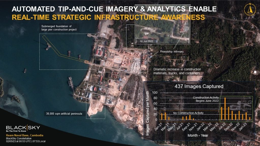
Geospatial intelligence over China’s secret naval base at Ream, Cambodia
Antecedent to these new developments this technology revealed that the rapid construction in Cambodia for the PLA Navy at the Ream. Activity at the site ‘tipped’ the constellation the arrival or departure of ships and ‘cued’ the satellites to collect imagery.
“We started monitoring this facility, at first at a low frequency, maybe once a week, once every couple weeks, then as we started to understand the pace of activity at this facility was picking up, we picked up the rate we were doing collection and analytics,” said BlackSky CEO Brian O’Toole, speaking at DGI London.
“And then that started getting us some interesting insights relating to the pace of construction, and ultimately to start to deliver information about how fast this is moving along, and potentially when this facility is going to come online.”
The Wall Street Journal was the first to report in 2019 that China had set up a second military base in Cambodia, at the Ream Naval Base. China and Cambodian government officials have publicly denied the rumours that they added Chinese military equipment to the Cambodian military installation, but US officials remain unconvinced.
This will be China’s second overseas military base. The first can be found in Djibouti next to the Doraleh multi-purpose port. Reportedly, the northern half of the base is where the new Chinese section can be found.
BlackSky provided Naval Technology with satellite imagery across a series of dates from August 2021 until late February 2023.
A geospatial intelligence analyst with knowledge of the site at Ream has reviewed the images obtained by Naval Technology.
The satellite image from 18 August 2021 shows the site as it was before intensive construction began. The base is ringed in by a perimeter fence.

While the analyst had viewed images from 2020 onwards, it was not until October 2021, that significant changes began to appear, with the construction of a road in China’s half of the base.
In June 2022 clearing of trees and grassland began, and on the southern shoreline construction began on a facility that was later determined to be the cement plant. This facility went on to provide materials for construction across the rest of the base.
The following months brought big changes, with a new pier, new buildings and a large area cleared for further construction. Shipping activity increases with the arrival of clamshell barges for dredging, with the vast plumes of silt brought up from the dredged soil this visible in the satellite imagery as the grey plumes stretching for hundreds of meters. Foundation laying had begun on a number of facilities, and in September 2022 the cement manufacturing facility was completed.

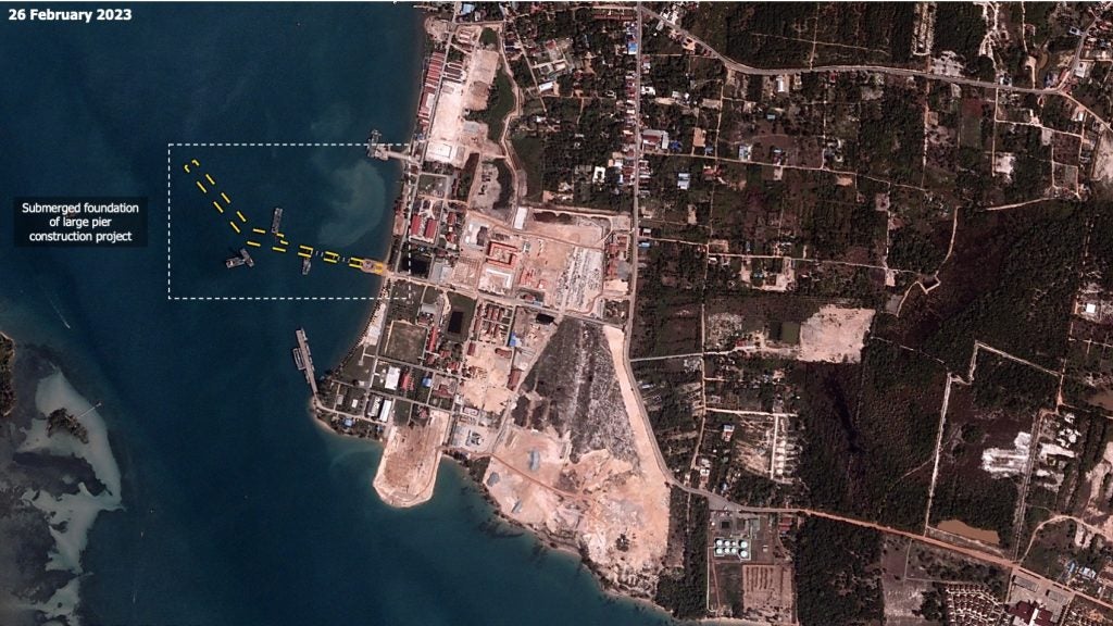
In October 2022 construction began on the second pier, and it is this pier that would later create controversy. A Radio Free Asia report from late February 2023 looked at satellite imagery of the naval base at Ream. That report had identified this pier as a temporary structure for construction materials and equipment, but this was later contradicted by an analyst with knowledge of the site after reviewing the BlackSky imagery provided to Naval Technology.

In the image from 5 February 2023, the analyst familiar with the site noted ferries arranged in a uniform line extending far out from the second pier they had been constructing. Barges had been working on extending the pier consistently at this point, with the shadow of a tall crane for inserting pilings visible across the waters.
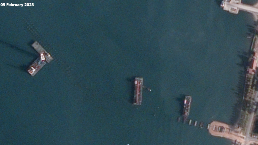
Close inspection of the satellite imagery from 5 February revealed rows of pilings to act as the support for a permanent pier, with dimensions far in excess of those required to ferry construction materials.
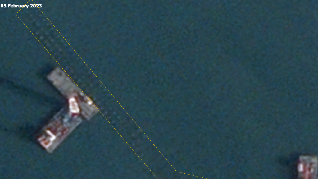
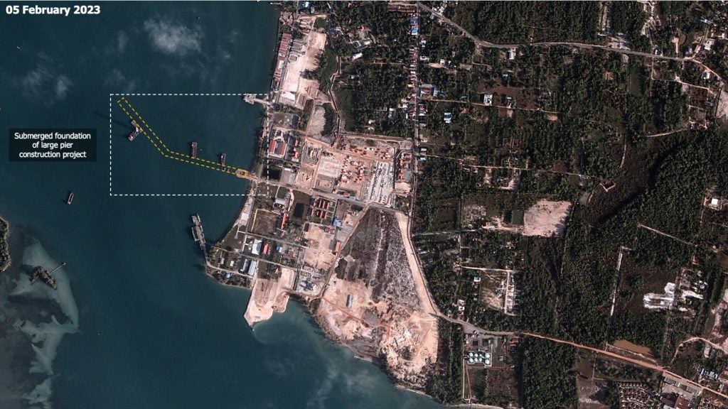
By the end of February 2023, the second pier had a total length of 685m, with 290m of usable docking space, and it had developed a distinctive shape, not seen at every staging area, but present at China’s only other naval base in foreign waters, off the coast of Djibouti.

Twenty-five additional buildings and two additional piers have been added in China’s half of the base since 2019. The southern half of the base, still considered to be under Cambodia’s control, has also increased in size, with two new buildings, a cement mixing facility, and the beginnings of a wharf on the installation’s southernmost point.
This site is strategically significant to the Chinese military since it provides a stronger presence in the region and supports their ongoing disputes in the South China Sea. The Strait of Malacca, where the Ream Naval Base is located, is a chokepoint for vessels transiting the region, and presents a challenging environment where navies must be at full alert. The low manoeuvrability means that conflict for passing ships can be devastating, and the presence of a naval base, with its supplies of fuel and ammunition, and the presence of medical facilities, offer strategic advantages to militaries stationed here.
The Spectra AI platform
While hardware in space and satellite images have drawn much attention, the development in software for users activating the geospatial intelligence system is also novel. Hosted on a responsive application, Spectra AI, the platform BlackSky has developed for users to access its constellation of satellites, works across a range of devices including handheld mobile phones, and allows images can be collected with only a few taps of the screen.
In a demonstration for Naval Technology, a database of internal tickets was made available, showing a map of thousands of points across the globe where BlackSky had made internal tasks for its satellites to collect images. Selecting a single collection site brought up a timetable, indicating how soon a satellite will be available to collect images from that location, and when successive images will be taken by future satellites.
Surprising levels of utility come from the inbuilt automation. Using outside data feeds that are a part of the system as a ‘tip’, satellite imagery collection can be ‘cued’ without further user instruction.
This was how BlackSky became the first geospatial intelligence company to collect images from Beirut after the massive explosion there on 4 August 2020. The outside data feed used to tip the system was from seismological sensors, and the satellites were cued to take photographs from the source of the disturbance.
“If there’s earthquakes the system will automatically respond. And it’s really powerful because you can have your entire workforce asleep or focused on other things, and the system will automatically carry out the task inside for you.”
Patrick O’Neil, chief innovation officer, BlackSky.
The Beirut explosion example was one of a range of examples where a user does not know where to look but has set up conditions to see images that match a certain criterion. Another example where Spectra AI has been used to task satellites in this manner can be found in Ukraine. Thermal imaging sensors at night have been used to tip the constellation to areas where there are indications of combat operations.
“We do that for natural disasters,” said Patrick O’Neil, chief innovation officer at BlackSky. “If there’s earthquakes the system will automatically respond. And it’s really powerful because you can have your entire workforce asleep or focused on other things, and the system will automatically carry out the task inside for you.”
Other forms of outside data feed can include the normal radio frequency correspondence associated with a plane or ship arriving at a location or departing. In this way activity can be monitored with satellite imagery collection from sites around the world simultaneously, and tasked to do so from a mobile device that is anywhere in the world.
“This is an airfield in Odessa, and this is an airfield we’ve been watching for some time. We monitor a lot of Russian and Ukrainian airfields as you can imagine,” said O’Neil bringing up a picture of an airbase on the Spectra AI platform on a laptop computer at DGI London. “And this is more of the automated analytics that we have here. So automatically detecting and counting these aircraft.”
When the satellite imagery is delivered, it is returned with analysis provided. Trained on thousands of images of ships and planes, the Spectra AI platform returns detailed descriptions of the images collected.
“We’re not just doing this for the handful of sites I’ve shown you, but we’re doing it for hundreds of thousands of facilities around the world all the time, all day, every day.”
Patrick O’Neil, chief innovation officer, BlackSky.
“When you have as much data as we have, you can start building up patterns, and understanding patterns of activity. So how many aircraft or ships or vehicles or whatever are typically at this facility?”
In the geospatial intelligence community this is a question normally undertaken on a weekly level, analysing data week-by-week. However, BlackSky’s constellation brings the aggregation of data down to hour-by-hour activity, allowing quick change detection.
“This can be particularly useful if you want to understand where military assets are deployed. If there’s an attack on this airbase, for example, which aircraft may have been damaged in that attack? We obviously track the movement of aircraft as well. So, are the Russians repositioning forces to prepare for increased aggression?”
“What’s really important to take away from this is that we can do all of this in-depth analysis for each of these facilities, but because it’s completely automated with AI, it means it can scale pretty much endlessly. So, we’re not just doing this for the handful of sites I’ve shown you, but we’re doing it for hundreds of thousands of facilities around the world all the time, all day, every day.”